
World
Published Aug 4, 2026Updated Aug 6 Major5
100%
Typhoon Dolphin approaches Okinawa with winds up to 216 kph
Typhoon Dolphin, the 2026 season's 13th typhoon, is moving westward toward Okinawa with sustained winds of 216 kph and central pressure of 945 hectopascals. Japan's weather agency warns of a 100 percent probability of violent winds in Okinawa, the Amami region, and nearby areas, plus potential rainfall exceeding 400 millimeters and waves of 9–11 meters, with closest approach expected August 7.
Quick Facts
- Typhoon Dolphin tracking westward
- Heavy rainfall expected
- Strong winds and high waves forecast
- Linear precipitation bands possible
- Landslide risk in earthquake-weakened terrain
Related Insights
TYPHOON DOLPHIN LIVE | Powerful Storm Targets Okinawa & Amami Islands | Japan News LIVE ET Now World · YouTube
TYPHOON DOLPHIN LIVE | Category 4 Storm Hits Japan's Ogasawara Islands | Deadly Typhoon Footage LIVE Times Now World · YouTube
TYPHOON DOLPHIN LIVE | Category 4 Storm Hits Japan's Ogasawara Islands | Deadly Typhoon Footage LIVE Times Now World · YouTube
TYPHOON DOLPHIN LIVE | Category 4 Storm Hits Japan's Ogasawara Islands | Deadly Typhoon Footage LIVE Times Now World · YouTube
Bão Dolphin tăng tốc hướng về Nhật Bản, quần đảo Ogasawara và đảo Okinawa vào vùng nguy hiểm Tạp chí VietTimes · YouTube
LIVE | Typhoon Dolphin Nears Japan! Live Footage Over Futami Port – Will It Hit Ogasawara? ET Now World · YouTube
Siêu bão Dolphin tăng tốc, sẽ tiến gần quần đảo Ogasawara và Okinawa Nhật Bản trong tuần này Báo Tiền Phong News · YouTube


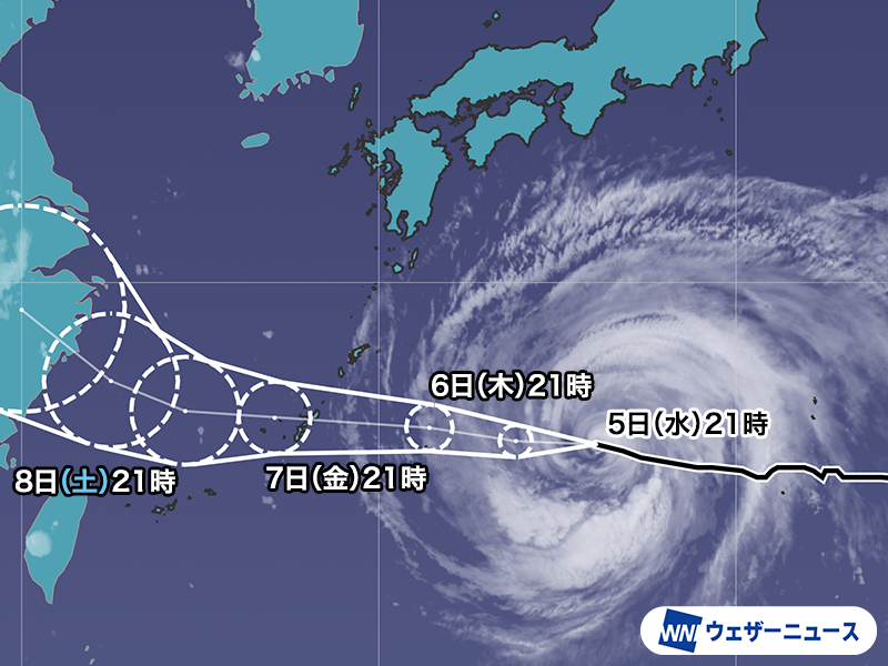

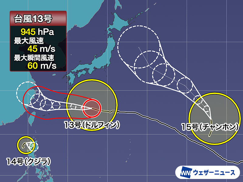
Typhoon Dolphin, the 13th typhoon of 2026, is tracking westward across the Pacific toward Okinawa and the Amami region with sustained dangerous conditions. As of early August 5, the storm was positioned south of the Ogasawara Islands, moving at 20 kilometers per hour with central pressure of 945 hectopascals, sustained winds of 45 meters per second, and gusts reaching 60 meters per second—equivalent to 216 kilometers per hour.
The Japan Meteorological Agency has issued warnings for multiple hazards across affected regions. Okinawa, the Amami region in Kagoshima Prefecture, and surrounding areas face a 100 percent probability of entering the storm's violent wind zone (gusts exceeding 25 meters per second) within the next five days. The Ogasawara island chain was forecast to experience waves up to 11 meters on August 5, declining to 9 meters on August 6. Wider areas along the Pacific coasts of Honshu, Shikoku, and Kyushu, as well as the Izu Islands, are experiencing elevated wave heights of 3 meters or more, with some locations expecting 4–5 meter waves.
Typhoon Dolphin is predicted to approach Okinawa's main island most closely on August 7, where it will maintain strength at approximately 950 hectopascals and 40 meters per second before gradually weakening. Prolonged adverse weather is expected through August 8 due to the storm's large size and slower-than-normal movement speed. The storm will then drift westward into the East China Sea. Meteorologists note particular concern for Okinawa, where the potential development of linear precipitation bands could produce rainfall totals near 400 millimeters. Residents in affected zones are advised to prepare for extended disruptions to transportation, including impacts on aviation and maritime traffic.
Significantly, the Japan Meteorological Agency confirmed that Typhoon Dolphin is not expected to directly impact Kumamoto Prefecture, which was devastated by a magnitude 7.1 earthquake on July 28. However, the agency warned that earthquake-weakened terrain in the region remains vulnerable to landslides even from moderate rainfall, requiring heightened vigilance despite the typhoon's indirect track.
The typhoon's name, Dolphin, was proposed by Hong Kong and references the white dolphin, a representative animal of the territory. Japan's meteorological services also note that August is statistically the month with the highest typhoon occurrence, averaging 5.7 storms annually.
Why This Matters
Typhoon Dolphin poses significant hazards to civilian infrastructure, transportation, and agriculture across Okinawa and the Amami region. Wind speeds of 216 kph and rainfall up to 400 mm will disrupt aviation and maritime traffic, trigger landslide risk in terrain already weakened by the July 28 Kumamoto earthquake, and cause measured damage to buildings and power systems. Peak impacts arrive August 7; effects extend through August 8 due to slow forward motion.
Timeline & Sources
Jul 28, 2026
WireMagnitude 7.1 earthquake strikes Kumamoto Prefecture
Aug 4, 2026
WireTyphoon Dolphin located south of Ogasawara Islands; central pressure 945 hPa, winds 45 m/s
Aug 7, 2026
WireClosest approach to Okinawa main island forecast; peak impacts expected
Aug 8, 2026
WireTyphoon moves into East China Sea; gradual weakening begins