
Emerging
Published Jun 27, 2026Updated Jun 27 Major4
91%
Magnitude 5.6 Earthquake Strikes Southeast of Pacitan, East Java; No Tsunami Risk
A magnitude 5.6 earthquake struck 86–96 kilometres southeast of Pacitan, East Java, on 27 June 2026 at 14:47 WIB, with no tsunami threat. The shallow tectonic tremor caused by subduction zone activity was felt across multiple districts in East and Central Java with intensity levels up to III on the Modified Mercalli Scale.
Quick Facts
- Magnitude 5.6 tectonic earthquake occurred
- Caused by subduction zone movement with thrust fault mechanism
- No tsunami generated or potential
- Tremors felt across multiple districts
- BMKG issued warnings for potential aftershocks

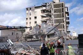



A magnitude 5.6 earthquake struck waters southeast of Pacitan, East Java, on Saturday, 27 June 2026, at 14:47 WIB (Western Indonesia Time), according to Indonesia's Meteorology, Climatology, and Geophysics Agency (BMKG). The epicentre was located 86–96 kilometres southeast of Pacitan at coordinates 8.96°–9.05° South Latitude and 111.11°–111.16° East Longitude, at a shallow depth of 10–53 kilometres below sea level. BMKG confirmed that the earthquake posed no tsunami threat to Indonesian waters.
The earthquake resulted from tectonic activity caused by subduction zone movement, with analysis indicating a thrust fault mechanism. BMKG reported that the tremor was felt across multiple districts in East and Central Java with varying intensity levels. Intensity III on the Modified Mercalli Scale was recorded in Pacitan, Wonogiri, Tulungagung, and Blitar, where vibrations were felt noticeably inside buildings. Intensity II was reported in Kulon Progo, Bantul, Sleman, Yogyakarta, Trenggalek, Malang, Nganjuk, Magetan, Klaten, Ponorogo, and Jember, where vibrations were felt by some people and light hanging objects swayed.
BMKG advised the public to remain cautious for potential aftershocks and to avoid buildings that may have been damaged by the earthquake. The agency urged residents to remain calm and to rely only on official information from verified BMKG channels, including its social media account @infoBMKG, website www.bmkg.go.id, and mobile applications. BMKG stated that it would continue monitoring seismic activity and provide updates to stakeholders and the public.
Why This Matters
This earthquake demonstrates ongoing tectonic activity along Indonesia's subduction zones, a critical seismic hazard region affecting millions of residents. Although this particular event posed no tsunami risk, it highlights the importance of public awareness, emergency preparedness, and reliance on official BMKG communications for accurate real-time seismic information. Understanding aftershock potential and building safety protocols remains essential for communities in seismically active areas of East Java.
Timeline & Sources
Jun 27, 2026
WireMagnitude 5.6 earthquake struck 86–96 km southeast of Pacitan, East Java at depth of 10–53 km
Jun 27, 2026
WireIndonesian news agencies (detikNews, Antara News) published reports on the earthquake
Jun 27, 2026
WireBMKG released official statement confirming earthquake and no tsunami risk
Jun 27, 2026
WireMagnitude 5.6 earthquake strikes 86–96 kilometres southeast of Pacitan, East Java, at shallow depth of 10–53 kilometres
Jun 27, 2026
WireBMKG releases official earthquake bulletin confirming no tsunami risk and providing technical parameters
Sources
- Gempa M 5,6 Guncang Pacitan JatimdetikNewsMediaJun 27, 2026
- Gempa magnitudo 5,6 guncang Pacitan dan tidak berpotensi tsunamiAntara News jatimMediaJun 27, 2026
- Gempa Bumi M5,6 – 86 km Tenggara PACITAN-JATIMBMKGMediaJun 27, 2026
- Gempa magnitudo 5,6 guncang Pacitan dan tidak berpotensi tsunamiANTARA News JambiMediaJun 27, 2026