
Sep 18·Science
Follow-up 2h ago6
91%
UK to reach 26°C next week as heat dome pushes warm air northward
The UK is forecast to experience temperatures up to 26°C next week as high pressure and warmer Atlantic air push north, with southern regions potentially warmer than Athens. While the warm spell may last through the week in southern England and Wales, a cold front could cut it short in Scotland and Northern Ireland midweek. The dry conditions worsen ongoing drought concerns, with the Environment Agency warning that most areas will need above-average rainfall through autumn and winter to exit drought status by April 2027.
Quick Facts
- High pressure building across the UK
- Warmer air drawn from subtropical Atlantic and continental Europe
- Heat dome phenomenon suppressing cloud formation
- Cold front approaching from the west
- Record number of days above 25°C exceeded in 2026
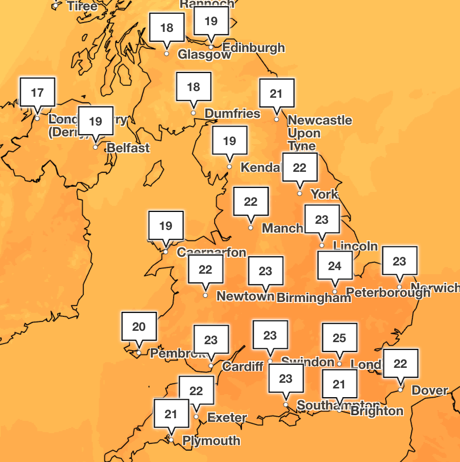



The UK is forecast to experience a warm spell next week, with temperatures in the south-east reaching up to 26°C—potentially warmer than Athens, which is forecast to remain below 24°C. The warm weather is being driven by high pressure building across the country and warmer air being drawn northward from the continental and subtropical Atlantic as a deep low-pressure system develops west of the UK. Most areas will experience above-average temperatures for late September, with Tuesday expected to be the warmest day of the week across southern England.
The duration and geographic extent of the warm spell vary by region. Southern areas of England and Wales are forecast to remain mostly dry and warm throughout the week, while Scotland and Northern Ireland may see the warmer period cut short by a cold front moving in from the west, which could bring rain and unsettled conditions midweek. The Met Office has indicated that "the prospect of one final heatwave before the end of the month is certainly not out of the question," though current forecasts do not meet formal heatwave criteria. In contrast, Netweather forecasters have stated there is "no sign" of a late September heatwave at present, expecting temperatures in the low to mid-20s rather than heatwave conditions.
2026 has already been a record-breaking year for warm days. By mid-September, the UK had exceeded 89 days above 25°C, surpassing the previous record of 89 days set in 1959. This follows the UK's hottest summer on record, with June, July, and August averaging 16.5°C. Earlier in September, a similar heat dome affected mainland Europe, bringing temperatures exceeding 40°C in parts of Spain and Portugal.
The warm and dry conditions present a challenge for water management. Reservoir and water storage levels remain critically low across much of the UK. The Environment Agency has warned the country will need above-average rainfall throughout autumn and winter for most areas to exit drought status by April 2027. Environment Agency chief executive Philip Duffy stated the drought situation "remains very serious," noting that "several reservoirs are concerningly low." Recent rainfall has fallen well short of seasonal requirements—by mid-September, locations such as Leconfield in East Yorkshire had received only 11% of normal September rainfall, and Durham just 14%, compared to the typical 50–60% by this point in the month.
Meteorologically, the warm spell is generated by a heat dome—a large area of high pressure that causes air to sink and warm through compression while suppressing cloud formation. Beyond next week, forecasters indicate that more unsettled conditions may return from the Atlantic, with longer-term projections showing conditions becoming changeable with spells of rain and temperatures returning to near normal. Some forecasts also reference a developing El Niño event in the tropical Pacific, which could bring wetter and stormier conditions to the UK in subsequent months.
Why This Matters
A week-long warm spell affecting the UK will drive temperatures 5–10°C above seasonal norms in the south, while dry conditions compound existing water storage deficits: reservoir levels remain critically low, and the Environment Agency has flagged that most regions require above-average rainfall through autumn and winter to exit official drought status by April 2027. Regional water utilities and agricultural sectors are directly exposed to continued precipitation shortfalls, and longer-term climate pattern shifts (referenced El Niño development) may alter UK weather systems through subsequent months, affecting water planning, energy demand, and seasonal forecasting.
Timeline & Sources
Sep 20, 2026
WireWeekend: cooler, changeable conditions dominate with rain and showers; southern areas experience mostly cloudy skies with drizzle; northern areas see sunny spells and blustery showers
Sep 21, 2026
WireSunday: early rain in far north and south clears to leave most areas dry with sunny spells; temperatures near seasonal average (15–21°C)
Sep 22, 2026
WireMonday and Tuesday: warmest days of the week; high pressure builds more widely; temperatures lift with increasing sunshine; humidity levels rise; early morning mist and fog possible in some areas
Sep 24, 2026
WireWednesday: brief spell of rain moves into northern areas; high pressure maintains dry conditions in the south
Sources
- UK weather: Summer warmth to return next week with 26C forecastBBCMediaSep 18, 2026
- ‘Final taste of summer’ for UK as heat dome sends temperatures risingThe IndependentMediaSep 18, 2026
- Is there a late September heatwave on the way?NetweatherMediaSep 19, 2026
- Where temperatures could hit 26°C this weekThe i PaperMediaSep 19, 2026
- UK set for one last heatwave ahead of AutumnThe IndependentMediaSep 19, 2026
- UK weather: Britain to be hotter than Athens next week as temperatures soar to 26CThe IndependentMediaSep 19, 2026