
Sep 27·Science
Follow-up 1h ago8
91%
Extratropical cyclone brings severe storms, hail risk to eight Brazilian states
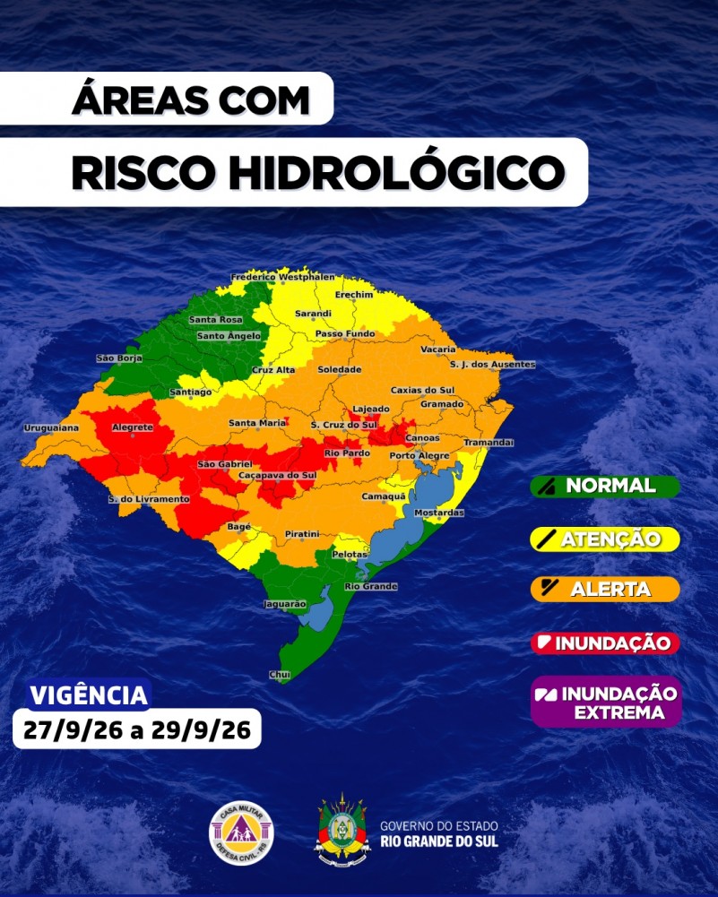
An extratropical cyclone forming Tuesday in southern Brazil will bring severe storms, hail, and intense rainfall (potentially exceeding 100–270 mm) to eight states, with wind gusts above 90 km/h. Nine major rivers in Rio Grande do Sul face inundation risk, and over 9,500 people were already affected by weekend hail damage.
Quick Facts
- Formation of extratropical cyclone
- Severe thunderstorms with hail
- Intense rainfall
- Strong wind gusts
- River inundation risk
/https://i.s3.glbimg.com/v1/AUTH_59edd422c0c84a879bd37670ae4f538a/internal_photos/bs/2026/3/Z/muxIyiRy2i1celt6xLWA/whatsapp-image-2026-09-26-at-19.16.41.jpeg)

An extratropical cyclone is forecast to form between late Monday night and early Tuesday morning (September 29) across southern Brazil, triggering severe weather across at least eight states. The system will bring intense rainfall, wind gusts exceeding 90 km/h, hail risk, and potential flooding. Brazil's National Meteorology Institute (Inmet) has issued orange-level alerts (danger) for Rio Grande do Sul and Santa Catarina, with yellow-level alerts (potential danger) extending across much of the southern and southeastern regions.
Rainfall projections are substantial. Rio Grande do Sul's Civil Defense reports accumulated precipitation between Sunday (27th) and Tuesday (29th) could range from 100–200 mm across the state, with some areas in the Campanha and Centro regions potentially exceeding 270 mm. Specific municipalities face severe risk: Dom Pedrito is forecast to receive around 115 mm on Tuesday alone, while Santana do Livramento and Rosário do Sul are each expected to receive approximately 105 and 63 mm respectively by Monday evening. Hourly rainfall rates could reach 30–60 mm/h in some areas, with 12-hour accumulations potentially surpassing 120 mm and 24-hour totals exceeding 170 mm in the most affected regions.
The cyclone formation is linked to the convergence of a warm front (warm, humid air mass) and a cold front advancing from lower latitudes. Meteorologists attribute the intense activity to an area of low pressure currently positioned north of Argentina, which is intensifying instability across the region. Wind gusts are expected to reach 90–100 km/h in affected areas, with the strongest conditions concentrated in the Fronteira Oeste, Campanha, Missões, Noroeste, Centro, and Nordeste regions of Rio Grande do Sul, as well as parts of Santa Catarina and Paraná.
Hydrological monitoring shows elevated risk for nine major rivers across Rio Grande do Sul. The Defesa Civil (State Civil Defense) has flagged inundation risks for the Caí, Quaraí, Ibicuí, Ibirapuitã, Jacuí, Santa Maria, São Sepé, Taquari, and Vacacaí rivers, with some—including the Jacuí and Rio dos Sinos—already at or above flood thresholds. Additional rainfall is expected to raise water levels further, increasing the probability of localized flooding, flash flooding in smaller waterways, and potential embankment overflow.
Damage from preceding weekend storms has already been documented. As of late Sunday (27th), Rio Grande do Sul's Civil Defense reported 9,517 people affected, 2,200 homes damaged, one injury, and no confirmed deaths. Santiago and Alegrete were the hardest hit, with approximately 5,000 and 2,000 residents affected respectively. Hail accumulation in some areas was so intense that ground surfaces appeared covered in ice.
The severe weather is forecast to persist through Tuesday morning and gradually weaken by Wednesday (30th). Conditions are expected to stabilize from Thursday (October 1st) onward, with predominantly clear skies and cooler temperatures across the region.
Entities
- Santiago (Rio Grande do Sul)
- Jacuí River
- Inmet (Instituto Nacional de Meteorologia)
- Defesa Civil do Estado (Rio Grande do Sul)
- Santana do Livramento (Rio Grande do Sul)
- Federal University of Santa Maria (UFSM)
- Murilo Lopes
- Cemaden (Centro Nacional de Monitoramento e Alertas de Desastres Naturais)
- Dom Pedrito (Rio Grande do Sul)
- Taquari River
Why This Matters
An extratropical cyclone affecting eight Brazilian states will bring severe rainfall (100–270 mm in some areas), wind gusts over 90 km/h, and hail through September 29–30. Nine major rivers in Rio Grande do Sul face inundation risk; pre-storm damage already affects 9,517 people and 2,200 homes. Agricultural regions (Campanha, Missões, Noroeste) and critical water infrastructure face measurable disruption and potential cascading flooding through early October.
Timeline & Sources
Sep 30, 2026
WireCyclone moves away; weather begins to improve; residual rain in northern RS and Região Metropolitana; cooler temperatures
Sources
- Rio Grande do Sul tem risco severo para chuva intensa e volumosaPortal do Estado do Rio Grande do SulMediaSep 27, 2026
- Com previsão de ciclone extratropical, instabilidade marca a última semana de setembro no RSGZHMediaSep 27, 2026
- Previsão do tempo no RS: segunda-feira será de chuva volumosa e terça, formação de cicloneG1MediaSep 28, 2026
- Rio Grande do Sul e Santa Catarina entram em alerta para tempestade intensaCNN BrasilMediaSep 28, 2026
- Temporais avançam pelo Sul nesta segunda; ciclone reforça chuva amanhãG1MediaSep 28, 2026
- Sob influência de ciclone extratropical, terça-feira terá tempestades e ventos de até 100 km/h no RSGZHMediaSep 28, 2026
- Ciclone provoca tempestades e risco de granizo em oito Estados nesta terçaGlobo RuralMediaSep 28, 2026
- Tempestades com queda de granizo, chuva intensa e rajadas de vento continuam a atingir o Rio Grande do Sul até terça (29)Portal do Estado do Rio Grande do SulMediaSep 28, 2026