
Science
Published Jul 29, 2026Updated Jul 31 Major8
100%
Super Typhoon Dolphin Intensifies to 306 km/h Gusts, Eyes Japan Next Week
Super Typhoon Dolphin has intensified to peak strength with gusts up to 306 km/h and is forecast to approach Japan's Ogasawara and Izu Islands early next week before potentially curving toward Kyushu and Okinawa. The storm represents the fifth typhoon in an above-average 2026 season.
Quick Facts
- Super Typhoon Dolphin intensified to extreme strength
- Central pressure forecast to drop to 905 hectopascals
- Maximum sustained winds of 55 m/s (198 km/h) near centre
- Gusts reaching 80–85 m/s (288–306 km/h)
- Typhoon moving west-northwest toward Japan


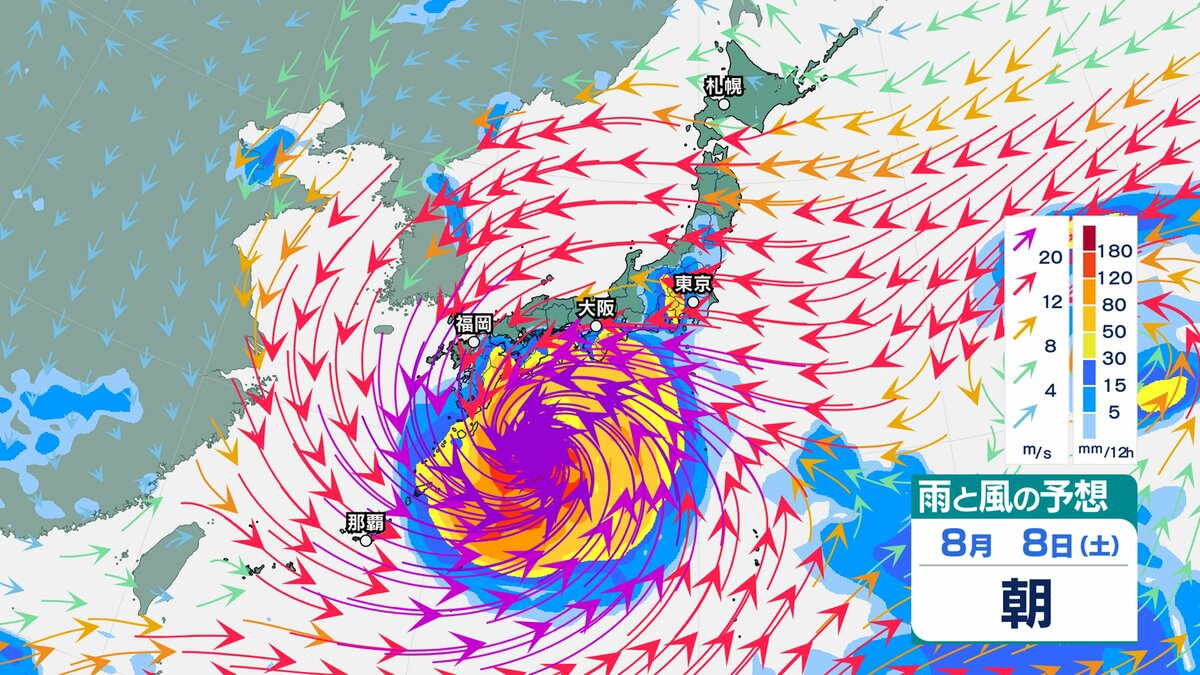

Super Typhoon Dolphin has intensified into one of 2026's strongest storms, with maximum sustained winds of 55 metres per second (198 km/h) near its centre and gusts reaching 80 metres per second (288 km/h) as of 31 July. The Japan Meteorological Agency forecasts the typhoon will reach peak intensity on 1 August with central pressure dropping to 905 hectopascals and gusts potentially reaching 85 metres per second (306 km/h). The storm is moving west-northwest at approximately 20 kilometres per hour from waters near Wake Island.
Most forecast models show Dolphin will approach the Ogasawara Islands between 3–4 August while still classified as "very strong," bringing extreme seas, violent winds, and heavy rainfall to the region. The Izu Islands are also forecast to experience rising waves from 4 August onward. Beyond 5 August, forecast uncertainty widens significantly; multiple numerical models suggest the typhoon could curve westward across the south of Japan, potentially affecting Kyushu and Okinawa from 6 August depending on the intensity and position of the Pacific high-pressure system.
Dolphin is the fifth typhoon to develop in July 2026, continuing an above-average year for typhoon formation. As of July, Japan has recorded approximately five more typhoons cumulatively than the historical average of 3.7 per month. Notably, 2026 marks only the third year since 1951 in which a typhoon has formed in every month from January through July, alongside 1965 and 2015. The typhoon's name "Dolphin"—proposed by Hong Kong—derives from the white dolphin (Chinese white dolphin), a marine mammal emblematic of Hong Kong.
The Japan Meteorological Agency, US military's Joint Typhoon Warning Center, and European Centre for Medium-Range Weather Forecasts are all tracking Dolphin's path, though predictions beyond five days carry heightened uncertainty. Residents in coastal and island regions have been advised to monitor official weather updates and prepare early for potential impacts.
Why This Matters
Super Typhoon Dolphin represents the fifth typhoon in an above-average 2026 Pacific season, with peak intensity forecast for 1 August at 85 m/s gusts. Japan's Ogasawara and Izu Islands face extreme seas and violent winds from 3–4 August onward; Kyushu and Okinawa may be affected from 6 August depending on the storm's track and the Pacific high-pressure system. Forecast uncertainty widens beyond five days, affecting emergency preparedness and maritime/aviation operations across Japan and adjacent waters. This is only the third year since 1951 in which typhoons have formed every month from January through July.
Timeline & Sources
Jul 29, 2026
WireTyphoon Dolphin at central pressure 955 hPa, maximum sustained winds 45 m/s, gusts 60 m/s; moving northwest at 15 km/h near Marshall Islands
Jul 30, 2026
WireTyphoon intensifies to central pressure 910 hPa, sustained winds 55 m/s, gusts 80 m/s; classified as 'furious' (猛烈な); moving west-northwest
Aug 4, 2026
WireForecast: typhoon near Ogasawara Islands, extreme seas and violent winds expected
Aug 6, 2026
WireForecast: possible impact on Kyushu and Okinawa depending on track and high-pressure system position
Related Signals
- ScienceGeographic Impact
7.1 Magnitude Earthquake Strikes Kumamoto, Triggers Tsunami Warning
Updated Jul 28
- ScienceGeographic Impact
Magnitude 7.1 earthquake strikes Kumamoto, Japan; tsunami advisory lifted
Updated Jul 29
- ScienceGeographic Impact
7.1 magnitude earthquake kills 13 in southern Japan, displaces 9,000+
Updated Jul 31
- ScienceGeographic Impact
Japan earthquake kills 34 as rescue efforts continue in extreme heat
Updated Jul 30
- ScienceRelated Topic
EF3 tornado strikes northeast Wisconsin, leaves 15,000+ without power
Updated Jul 28
- ScienceRelated Topic
Powerful summer storm brings flash flooding threat to Northeast through Thursday
Updated Jul 28
- ScienceRelated Topic
Three Greek firefighters killed as Crete wildfire forces 8,000 evacuations
Updated Jul 31
Sources
- 【台風情報】台風13号は猛烈な勢力へ 日本列島に接近する予測も…今後の進路は?【気象庁・雨風の予想シミュレーション】TBS NEWS DIGMediaJul 29, 2026
- 台風13号…気象庁の予想進路、米軍・ヨーロッパの見方 日本への影響は福井新聞社MediaJul 28, 2026
- 猛烈な勢力の台風13号(ドルフィン) 今年最強勢力の予想 小笠原諸島は荒天警戒ウェザーニュースMediaJul 30, 2026
- 台風13号 猛烈な勢力で日本のはるか南東を西へ(ウェザーマップ)Yahoo!ニュースMediaJul 30, 2026
- 猛烈な勢力の台風13号(ドルフィン) 来週はじめ頃は小笠原諸島で荒天警戒 早めの対策をウェザーニュースMediaJul 30, 2026
- 【台風情報】九州・沖縄に接近の可能性も...猛烈な勢力の「台風13号」最大瞬間風速 85m/s予想…8月10日(月)にかけての雨・風シミュレーション【気象庁31日午前6時45分発表】 | 岡山・香川のニュース | 天気 | RSK山陽放送TBS NEWS DIGMediaJul 30, 2026
- Tufão extremamente forte com rajadas de 306 km/h avança em direção ao JapãoPortal MieMediaJul 31, 2026
- Ciclone Dolphin assusta meteorologistas e promete ventos de 300 km/h até 01/08Diário do ComércioMediaJul 31, 2026