
Sep 21·Science
Follow-up 2h ago Major7
96%
Hurricane Polo intensifies to Category 5 off Mexico, threatens heavy flooding
Hurricane Polo has intensified to one of the strongest Pacific cyclones in decades, reaching Category 5 status with 165 mph winds before fluctuating to Category 4. Expected to skirt Mexico's southwestern coast without direct landfall, it poses severe flooding and mudslide risks from 3 to 6 inches of rainfall. El Niño strengthened the system, while Tropical Storm Odalys also strengthened to Category 1 hurricane status in the same basin.
Quick Facts
- Hurricane Polo intensified to Category 5, then fluctuated to Category 4
- Polo classified as 'extremely dangerous'
- Hurricane-force winds extending 40 miles from center
- Tropical storm-force winds extending 105 miles from center
- Classes suspended in affected Mexican areas
Related Insights
State of Emergency declared ahead of El Niño season FOX 11 Los Angeles · YouTube
Hurricane Polo Explained (2026): From Tropical Storm to Category 5 | Weather Lesson Sy · YouTube
Hurricane Polo Targets Mexico’s Coast! Storm Strengthens As Heavy Rain And Winds Threaten Region MIRROR NOW · YouTube
The Pacific Coast Is About To Turn Deadly This Week — Here's Why Breakpoint · YouTube
This Storm Could Hit Category 5 Before It Reaches The Pacific Coast Red Sky Bulletin · YouTube
EL NIÑO FUELS HURRICANE SEASON | Nolo and Polo Bring Major Problems to Hawaii and Mexico Josh's Severe Weather · YouTube
⚠️ ¡ALERTA! Tormenta Tropical Polo amenaza México 🌪️ Noticias LAT | AHORA · YouTube
The Strongest El Niño Ever Recorded Just Built a Monster Off Mexico's Coast Global Arizona · YouTube
A MASSIVE Hurricane is coming To Mexico- And NOAA Just Confirm Is A Category 5 WEATHER REPORTS · YouTube
Polo Intensifies Within Hours: Is a Major Hurricane Coming? The FlashPoint · YouTube




Hurricane Polo has rapidly intensified into one of the most powerful Pacific cyclones in decades, reaching Category 5 status with peak sustained winds of 165 mph before fluctuating to Category 4 (150 mph) as it churned off Mexico's southwestern coast. The U.S. National Hurricane Center classified Polo as "extremely dangerous" and forecast it would skirt Mexico's Pacific coast without making direct landfall, instead turning sharply northwest and moving west-northwest over the coming days. Positioned approximately 210 miles south of Zihuatanejo and 320 miles southeast of Manzanillo, Mexico, Polo represents one of only three Category 5 hurricanes of the 2026 Pacific season, following Genevieve and Lowell.
Heavy rainfall poses the primary threat despite the storm remaining offshore. The National Hurricane Center forecast 3 to 6 inches of rain for Guerrero and Michoacán states, with isolated totals near 12 inches possible, creating risks of life-threatening flash flooding and mudslides. Mexican authorities suspended classes in affected areas and closed ports in Guerrero and Michoacán, while the U.S. Embassy issued alerts instructing citizens to avoid beaches and water. Mexican President Claudia Sheinbaum said experts indicated the hurricane was unlikely to make landfall. Hurricane-force winds extend up to 40 miles from the storm's center, with tropical storm-force winds reaching 105 miles away, affecting coastal areas including Colima, Oaxaca, and Jalisco.
Scientists attributed Polo's rapid intensification to a strengthening El Niño system that has supercharged the Pacific basin. The National Hurricane Center called the 24-hour intensification "truly remarkable." Kristen L. Corbosiero, professor at the University at Albany's Department of Atmospheric & Environmental Sciences, stated: "This is one of the strongest storms ever in the (Pacific) Basin." Wind speeds compare to few hurricanes in recent decades, primarily Hurricane Patricia (215 mph in 2015).
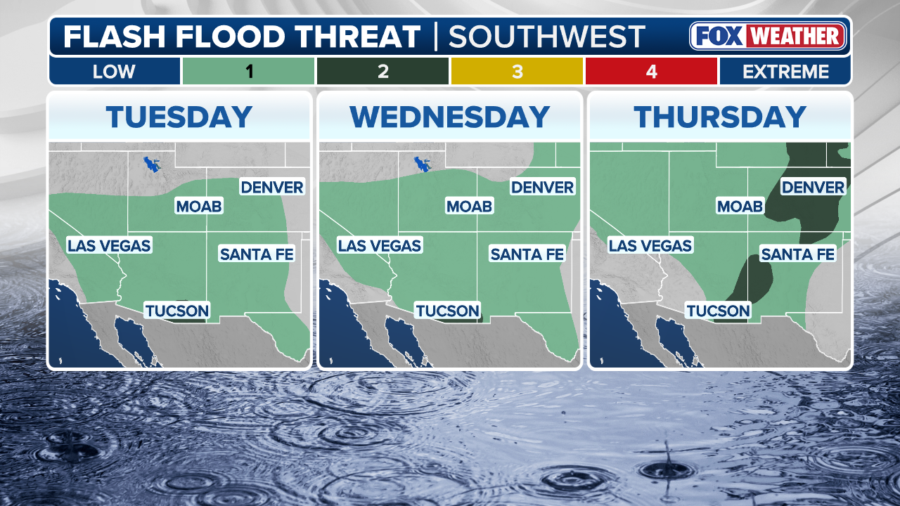
Meanwhile, Tropical Storm Odalys strengthened to Category 1 hurricane status, positioned 1,295 miles off the southern Baja California peninsula with 75 mph sustained winds. Odalys poses no immediate threat to land but may interact with Polo in coming days, potentially bringing additional tropical moisture to the region. Forecasters noted that Polo's moisture was already expected to enhance monsoon thunderstorms and flood threats across the U.S. Southwest, particularly New Mexico, beginning mid-week. The combined effect of two Pacific systems and El Niño has produced 18 named storms across the Central and Eastern Pacific this season with over two months remaining.
Residents along Mexico's Pacific coast expressed concern about potential damage. Concepción López Villegas, who operates a seaside restaurant in Lázaro Cárdenas, Michoacán, stated: "We're worried and trying to protect our businesses. And of course, we're sad because it's our heritage, our legacy that from one moment to another could be destroyed." Coastal erosion from previous storms this year had already prompted emergency declarations from multiple California counties.
Why This Matters
Hurricane Polo's rapid intensification to Category 5 (165 mph sustained winds) creates measurable impacts: 3–6 inches of rainfall (up to 12 inches in isolated areas) poses flash-flooding and mudslide risks for Mexico's Guerrero and Michoacán states; Mexican authorities have suspended classes and closed ports; the U.S. Embassy has issued travel alerts; additional tropical moisture is forecast to enhance monsoon flooding across the U.S. Southwest. Concurrent development of Tropical Storm Odalys (now Category 1) and El Niño strengthening may compound regional moisture and flood threats. Coastal communities and tourism-dependent businesses face economic exposure; insurance and emergency response systems in affected Mexican and U.S. states are activated.
Timeline & Sources
Sep 21, 2026
WireTropical Storm Polo strengthened to Category 1 hurricane; forecast to become major hurricane by midweek
Sep 21, 2026
WireTropical Storm Odalys positioned 1,400+ miles west-southwest of Baja California with 45 mph winds; expected to become hurricane by midweek
Sep 23, 2026
WirePolo at Category 4 strength with 241 km/h sustained winds; Odalys strengthened to Category 1 hurricane
Sep 23, 2026
WireNational Hurricane Center labeled Polo 'extremely dangerous'; Odalys confirmed as Category 1 hurricane with 120 km/h winds
Related Signals
Sources
- Polo Odalys Fay Major Hurricane Mexico 8d857bb0cb9db18befb4d23b04feca32apWireSep 21, 2026
- Horacan Polo Mexico Odalys E87d59c2ec7a2e33c3a19593396d1764apWireSep 21, 2026
- Huracan Polo Mexico Odalys Pacifico Atlantico 19a1ac887074035b2288b851c6d6aeb7apWireSep 23, 2026
- Hurricane Polo Mexico Fe846bf4bc35ec5bdfa2e9014b7fe3e8apWireSep 23, 2026
- Hurricane Polo Mexico A6c1c226c878a236442a8e1a7f37211bapWireSep 22, 2026
- Polo now a Category 1 hurricane, expected to strengthen and fuel Southwest flood threat amid active PacificFOX WeatherMediaSep 21, 2026
- Tropical Storm Polo is strengthening. Could it mean more rain for California?Los Angeles TimesMediaSep 21, 2026