
Oct 2·Science
Follow-up 3h ago5
91%
Typhoon Choi-wan approaches Ogasawara Islands with severe winds, high waves expected
Typhoon Choi-wan is tracking toward the Ogasawara Islands with intense winds and high waves forecast for October 4–6, 2026. The system is expected to pass east of Honshu with minimal direct impact on the mainland but significant swell effects along the Pacific coast.
Quick Facts
- Typhoon Choi-wan (Typhoon No. 27) tracking northeastward
- Intensifying from strong to very strong status
- Severe winds and high waves affecting Ogasawara Islands
- Transitioning to temperate cyclone by October 7
- Passing east of Honshu

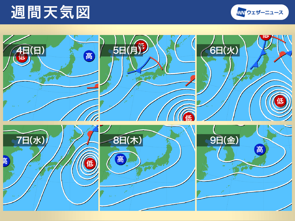

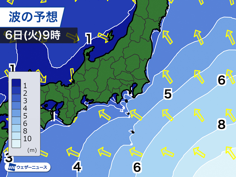
Typhoon Choi-wan (Typhoon No. 27) is tracking northeastward toward the Ogasawara Islands, with the Japan Meteorological Agency issuing warnings for extremely severe conditions from October 4–6, 2026. As of October 3 at 9 p.m., the large and powerful typhoon was located in the waters near the Ogasawara Islands, moving north-northeast at approximately 15 km/h. The central pressure stood at 960 hPa, with sustained winds of 40 m/s and gusts reaching 55 m/s.
The typhoon is expected to intensify further, reaching "very strong" status by the morning of October 4 with maximum sustained winds reaching 45 m/s and gusts up to 60 m/s. Peak intensity is forecast for October 4–5, when the typhoon will be closest to the Ogasawara Islands. Predicted conditions include maximum sustained winds of 23 m/s (gusts 35 m/s) and waves reaching 6–8 meters with swell effects across October 4–6. The mountainous terrain and exposed position of the Ogasawara Islands will experience severe weather during this period.
By October 6, the typhoon is forecast to move east of Honshu while maintaining strong status (40 m/s sustained winds, 60 m/s gusts). By October 7, it is expected to transition into a temperate cyclone near the Kurils, moving northeast at 65 km/h. Although the typhoon's closest approach will be to the Ogasawara Islands rather than Honshu proper, the broader Pacific coastal region and waters east of Japan are under alert for heavy swells and strong winds from the passing system.
The timing and exact track remain subject to revision. The Japan Meteorological Agency, Weather News, and Fuji News Network continue to issue updated forecasts every 6 hours. This typhoon represents an accelerated pace for 2026: it is the earliest occurrence of a Typhoon No. 27 on record (6th earliest in statistical history), and Japan has experienced monthly typhoon activity from January through October—a pattern that has occurred only three times since 1951 (1965, 2015, and 2026). Residents and maritime operators are advised to monitor the latest official guidance closely.
Why This Matters
Typhoon Choi-wan poses direct hazard to the Ogasawara Islands with sustained winds 45 m/s, gusts 60 m/s, and waves 6–8 m expected October 4–5; maritime operations, island residents, and Pacific coastal communities face elevated risk from swell effects through October 6. The system's transition to a temperate cyclone by October 7 marks the formal end of active tropical wind threat, though residual swells will persist. Japan's 2026 typhoon pattern (earliest Typhoon No. 27 on record; full-year activity January–October matching only 1965 and 2015) affects seasonal resource and emergency planning assumptions for the remainder of the year.
Timeline & Sources
Oct 2, 2026
WireJMA official forecast issued; Typhoon Choi-wan located at Mariana Islands, central pressure 985 hPa, max winds 25 m/s, gusts 35 m/s; forecast to reach Ogasawara waters as very strong by October 4–5
Oct 3, 2026
WireWeather News update: Large and strong typhoon 27 near Mariana Islands at 3 p.m., moving north-northeast 20 km/h, pressure 960 hPa, winds 40 m/s, gusts 55 m/s; forecast to intensify to very strong near Ogasawara by early next week
Oct 6, 2026
WireTyphoon 27 moves east of Honshu, downgrading to strong status; pressure rises to 950 hPa, winds 40 m/s, gusts 60 m/s
Oct 7, 2026
WireTyphoon 27 transitions to temperate cyclone near Kurils; movement accelerates to 65 km/h northeast; wind speed 35 m/s, gusts 50 m/s
Related Signals
- ScienceRelated Topic
Gandak River Sets Record High, Breaches Embankments in Bihar
Follow-up 3d ago
- ScienceGeographic Impact
Komagatake Volcano Alert Raised to Level 2; Small Eruption Possible
Follow-up 1d ago
- ScienceRelated Topic
Tokyo's 34-day rain streak ends; weather shifts to sun in October
Follow-up 4d ago
- ScienceRelated Topic
Extratropical cyclone brings severe storms and flooding risk to southern Brazil
Follow-up 3d ago
Sources
- 【進路予想】台風27号“チョーイワン” 4日から5日にかけて「非常に強い」勢力で小笠原近海へ…7日には日本の東へ達する見通し<気象庁15時45分発表>Yahoo!ニュースMediaOct 2, 2026
- 週間天気予報 来週初めは広範囲で雨 台風27号は小笠原諸島方面へウェザーニュースMediaOct 2, 2026
- 【台風情報】大型で強い台風27号の進路予想 3日午後9時現在、小笠原近海、中心気圧960ヘクトパスカル 4日午前9時には非常に強い勢力になる予想FNNプライムオンラインMediaOct 3, 2026
- 大型で強い台風27号(チョーイワン) 小笠原諸島方面へ 本州からは離れて通過予想ウェザーニュースMediaOct 3, 2026
- 全般気象解説情報(台風第27号)(第3報)=気象庁発表(4日4時51分) :気象解説情報沖縄タイムス社MediaOct 3, 2026